
2026-10-14 東京大学
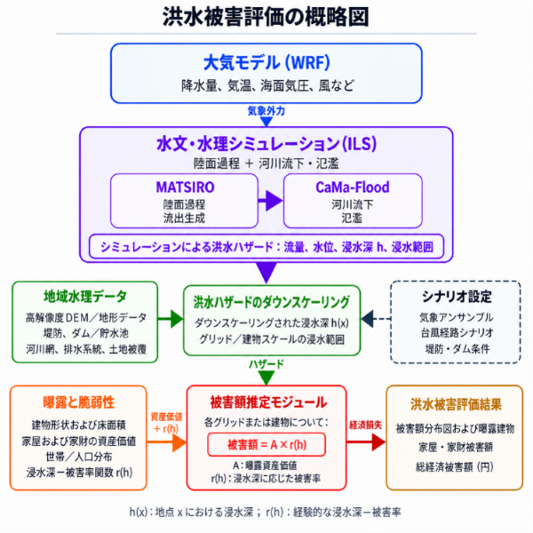
本研究で用いたインパクトベース洪水被害評価の概略図
<関連情報>
台風19号(2019年)における台風の進路変動と堤防高変動の影響下における、日本における洪水被害のインパクトベース評価 Impact-based flood-damage assessment in Japan under longitudinal typhoon-track perturbations and levee-height variations during Hagibis (2019)
Xiaoyang Li, Kei Yoshimura & Hironori Fudeyasu
Communications Earth & Environment Published:13 October 2026
DOI:https://doi.org/10.1038/s43247-026-04077-8
Abstract
Impact-based flood-damage assessment integrates hydrometeorological information with vulnerability and exposure data to generate comprehensive evaluation of flood damage. This study uses the Integrated Land Simulator to assemble an impact-based flood-damage assessment framework for Typhoon Hagibis (2019), one of the most powerful typhoons to strike Japan in recent years. To systematically evaluate how typhoon-track position and levee height influence flood damage, we conduct longitudinal typhoon-track perturbation experiments and levee-height variation scenario analyses. Here we show that the flood damage is highly sensitive to small typhoon-track shifts, with a 0.2° longitudinal shift causing an average damage difference of 83.3 billion JPY. A 1.0° eastward shift causes the highest damage in Kanto and across Japan, mainly around Tokyo, while 1.6° and 0.4° westward shifts produce the greatest damage in Kinki and Chubu, mainly around Osaka and Nagoya, respectively. The levee-height sensitivity experiments show an average flood-damage reduction of approximately 9.1 billion JPY for each 10% increase in levee height.

