
2026-06-18 筑波大学
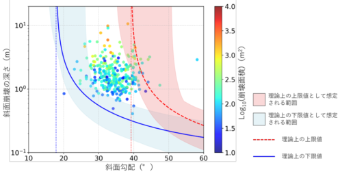
図 本研究で明らかになった斜⾯勾配と崩壊の厚さの関係
プロットの⾊は斜⾯崩壊の⾯積を表す。
<関連情報>
- https://www.tsukuba.ac.jp/journal/biology-environment/20260618141500.html
- https://www.tsukuba.ac.jp/journal/pdf/p20260618141500.pdf
- https://www.nature.com/articles/s41598-026-46714-4
火成岩地帯における航空レーザー測量データを用いた地形差分解析により明らかになった降雨起因の斜面崩壊の深さ Depth of rainfall induced landslides revealed by DEM of difference analysis using airborne LiDAR data in igneous terrains
Yuki Kudo,Taro Uchida & Misa Tsushima
Scientific Reports Published:11 April 2026
DOI:https://doi.org/10.1038/s41598-026-46714-4
Abstract
Landslide areas and depths were investigated using a digital elevation model (DEM) of difference (DoD) analysis based on pre- and post-rainfall airborne laser survey data. Three regions, consisting predominantly of granite or granodiorite bedrock, were selected as study sites: (A) the Noborikawa River Basin, (B) the Serizawa and Iriyamazawa Basins, and (C) the Uchikawa River Basin. Site C features gentler slopes than A and B. Although, assuming scale-invariant geometry, landslide depth is theoretically expected to depend on area, this was not observed, especially for shallow landslides. However, in all three regions, the landslide area was not a dominant determining factor for the depth of particularly shallow landslides. At site C, the landslide depth did not correlate with area, while at sites A and B it showed only a weak dependence. In both regions, gentle slopes showed a decreasing lower envelope of the landslide depth with increasing slope angle, while steep slopes showed a decreasing upper envelope. The results align with infinite slope theory, suggesting that landslide depth is controlled by mechanical equilibrium and maximum soil depth on steep slopes, rather than landslide area.
