2026-08-25 オックスフォード大学
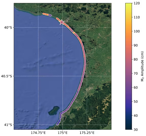
Tidal amplitude of the South Taranaki Bight as observed from satellite-imagery, showing tidal height variations of nearly 1 meter across the bight. Image credit: Dr Michael Hart-Davis (DGFI-TUM)
<関連情報>
- https://www.ox.ac.uk/news/2026-08-24-satellite-images-reveal-that-tides-can-vary-by-almost-a-metre-across-a-single-bay
- https://www.nature.com/articles/s43247-026-03943-9
衛星画像から得られた海岸線時系列データから観測された、海岸規模の潮汐変動 Beach scale tidal variations observed from satellite-derived shoreline time series
Michael G. Hart-Davis,Thomas Monahan,Kilian Vos & Ole B. Andersen
Communications Earth & Environment Published:25 August 2026
DOI:https://doi.org/10.1038/s43247-026-03943-9
Abstract
Coastal tidal dynamics play a crucial role in a variety of biogeophysical processes, ranging from compound flooding to sediment transport. Satellite altimetry has revolutionized our understanding of ocean tides, but coastal regions remain challenging for satellite altimetry-based observations. In recent years, important efforts have been made to produce shoreline measurements from satellite optical imagery. These datasets raise the question of whether shoreline observations can resolve tidal dynamics at fine coastal scales. Here, we show that shoreline measurements provide fine-scale insights into tidal characteristics, demonstrating variability at beach scales across the Pacific Rim. We explore how both harmonic analysis and response-based methods can be applied to these data to study a range of tidal constituents. Our results are contrasted with in situ measurements and state-of-the-art models as well as with wide-swath satellite observations. We demonstrate that satellite-derived shoreline measurements are a valuable resource for tidal research, particularly for model validation and the study of tidal constituent variability in the coastal zone.