シミュレーションは、リスクの高い地域に住む人々への早期警告システムになる可能性があります。 Simulations could become an early warning system for people living in high-risk areas
2022-07-27 ノースウェスタン大学
<関連情報>
- https://news.northwestern.edu/stories/2022/07/model-developed-to-predict-landslides-along-wildfire-burn-scars/
- https://nhess.copernicus.org/articles/22/2317/2022/
WRF-Hydroを用いた火傷跡における陸上流および河川流による土石流の発生しやすさのシミュレーションの機能拡張 Augmentation of WRF-Hydro to simulate overland-flow- and streamflow-generated debris flow susceptibility in burn scars
Chuxuan Li, Alexander L. Handwerger, Jiali Wang, Wei Yu, Xiang Li, Noah J. Finnegan, Yingying Xie, Giuseppe Buscarnera, and Daniel E. Horton
Natural Hazards and Earth System Sciences Published: 27 Jul 2022
DOI:https://doi.org/10.5194/nhess-22-2317-2022

Abstract
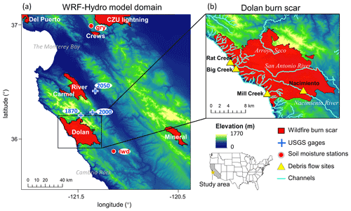
In steep wildfire-burned terrains, intense rainfall can produce large runoff that can trigger highly destructive debris flows. However, the ability to accurately characterize and forecast debris flow susceptibility in burned terrains using physics-based tools remains limited. Here, we augment the Weather Research and Forecasting Hydrological modeling system (WRF-Hydro) to simulate both overland and channelized flows and assess postfire debris flow susceptibility over a regional domain. We perform hindcast simulations using high-resolution weather-radar-derived precipitation and reanalysis data to drive non-burned baseline and burn scar sensitivity experiments. Our simulations focus on January 2021 when an atmospheric river triggered numerous debris flows within a wildfire burn scar in Big Sur – one of which destroyed California’s famous Highway 1. Compared to the baseline, our burn scar simulation yields dramatic increases in total and peak discharge and shorter lags between rainfall onset and peak discharge, consistent with streamflow observations at nearby US Geological Survey (USGS) streamflow gage sites. For the 404 catchments located in the simulated burn scar area, median catchment-area-normalized peak discharge increases by ∼ 450 % compared to the baseline. Catchments with anomalously high catchment-area-normalized peak discharge correspond well with post-event field-based and remotely sensed debris flow observations. We suggest that our regional postfire debris flow susceptibility analysis demonstrates WRF-Hydro as a compelling new physics-based tool whose utility could be further extended via coupling to sediment erosion and transport models and/or ensemble-based operational weather forecasts. Given the high-fidelity performance of our augmented version of WRF-Hydro, as well as its potential usage in probabilistic hazard forecasts, we argue for its continued development and application in postfire hydrologic and natural hazard assessments.


