2026-08-18 パシフィック・ノースウェスト国立研究所(PNNL)
<関連情報>
- https://www.pnnl.gov/publications/predicting-water-age-improve-estimates-water-availability-within-watersheds
- https://agupubs.onlinelibrary.wiley.com/doi/full/10.1029/2024MS004765
水追跡機能を備えた水文モデルにおける水の移動時間と水文トレーサーの動態を推定するための逐次降水入力タグ付け(SPIT) Sequential Precipitation Input Tagging (SPIT) to Estimate Water Transit Times and Hydrologic Tracer Dynamics Within Water-Tagging Enabled Hydrologic Models
Zachariah Butler, Stephen Good, Huancui Hu, Xingyuan Chen, Aubrey Dugger
Journal Advances in Modeling Earth Systems Published: 16 October 2025
DOI:https://doi.org/10.1029/2024MS004765
Abstract
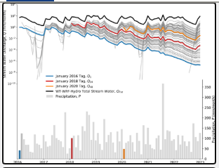
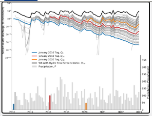
Determining the age distribution of water exiting a catchment is important for understanding groundwater storage and mixing. New water-tagging capabilities within models track precipitation events as they move through simulated storages, yet forward modeling of individual events may not systematically capture the full transit time distribution (TTD). Here, we present a “sequential precipitation input tagging” (SPIT) framework to tag all input precipitation at regular intervals during extended model simulations. Monthly tags over 7 years were applied at six National Ecological Observatory Network sites to calculate TTDs and derive mean virtual tracer age,ーTV, fractions of young water, Fyw, and hydrologic tracer concentrations (water isotopes δ18O and δ2H) within a tagging enabled version of the Weather Research and Forecast hydrologic model (WRF-Hydro). Throughout seven simulation years, the fraction of simulated discharge derived from tagged events, Ftag, increased each year, with the final year’s Ftag ranging from 66% to 100% and highlights the need to apply SPIT over many years to understand TTDs. When the Ftag was >75%, simulated ーTV ranged 179–923 days and Fyw 0.6%–23.9%, with daily values exhibiting a power-law relationship with precipitation, discharge, and groundwater. Through implementation of SPIT, we find this hydrologic model configuration performs poorly in estimation of ーTV and Fyw (root mean squared error of 469 days and 14.4% respectively), suggesting it misrepresents subsurface mixing. Thus, the SPIT framework provides a reproducible approach to calculate watershed transit times within tagging enabled models and thereby assess and improve representation of hydrologic processes.