2024-01-08 オランダ・デルフト工科大学(TUDelft)
◆研究者たちは常設のレーザースキャナーを使用し、新しい数学的手法により細かな変化を抽出。この手法は国際的にも氷河や地滑り、樹冠の成長のモニタリングに応用されている。今後は将来の沿岸変化を予測する「AdaptCoast」プロジェクトに着手し、物理的な要因だけでなく人為的な影響も考慮する模擬を行う。
<関連情報>
- https://www.tudelft.nl/en/2024/citg/unique-permanent-coastal-observation-detects-minimal-changes
- https://www.sciencedirect.com/science/article/pii/S2667393223000261
- https://www.nature.com/articles/s41597-022-01291-9
常設レーザースキャニングの時系列データから砂浜の変化を統計的に評価する Statistically assessing vertical change on a sandy beach from permanent laser scanning time series
Mieke Kuschnerus, Roderik Lindenbergh, Sander Vos, Ramon Hanssen
ISPRS Open Journal of Photogrammetry and Remote Sensing Available online: 27 December 2023
DOI:https://doi.org/10.1016/j.ophoto.2023.100055
Highlights
•Insight in quality of vertical change estimates from permanent laser scanning of a sandy beach.
•Identification of small-scale long term processes using multiple hypothesis testing on permanent laser scanning data.
•Comparison of level of detection with minimal detectable bias for multiple epochs of elevation estimates.
Abstract
In the view of climate change, understanding and managing effects on coastal areas and adjacent cities is essential. Permanent Laser Scanning (PLS) is a successful technique to not only observe notably sandy coasts incidentally or once every year, but (nearly) continuously over extended periods of time. The collected point cloud observations form a 4D point cloud data set representing the evolution of the coast provide the opportunity to assess change processes at high level of detail. For an exemplary location in Noordwijk, The Netherlands, three years of hourly point clouds were acquired on a 1 km long section of a typical Dutch urban sandy beach. Often, the so-called level of detection is used to assess point cloud differences from two epochs. To explicitly incorporate the temporal dimension of the height estimates from the point cloud data set, we revisit statistical testing theory. We apply multiple hypothesis testing on elevation time series in order to identify different coastal processes, like aeolian sand transport or bulldozer works. We then estimate the minimal detectable bias for different alternative hypotheses, to quantify the minimal elevation change that can be estimated from the PLS observations over a certain period of time. Additionally, we analyse potential error sources and influences on the elevation estimations and provide orders of magnitudes and possible ways to deal with them. Finally we conclude that elevation time series from a long term PLS data set are a suitable input to identify aeolian sand transport with the help of multiple hypothesis testing. In our example case, slopes of 0.032 m/day and sudden changes of 0.031 m can be identified with statistical power of 80% and with 95% significance in 24-h time series on the upper beach. In the intertidal area the presented method allows to classify daily elevation time series over one month according to the dominating model (sudden change or linear trend) in either eroding or accreting behaviour.
Graphical abstract

オランダ、Kijkduin海岸砂丘システムの高解像度4D地上レーザースキャンデータセット A high-resolution 4D terrestrial laser scan dataset of the Kijkduin beach-dune system, The Netherlands
Sander Vos,Katharina Anders,Mieke Kuschnerus,Roderik Lindenbergh,Bernhard Höfle,Stefan Aarninkhof & Sierd de Vries
Scientific Data Published:28 April 2022
DOI:https://doi.org/10.1038/s41597-022-01291-9

Abstract
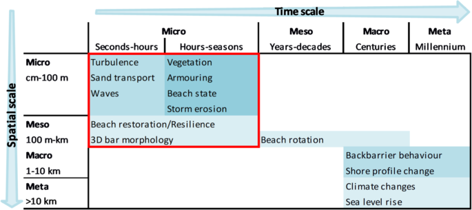
Sandy coasts form the interface between land and sea and their morphologies are highly dynamic. A combination of human and natural forcing results in morphologic changes affecting both nature values and coastal safety. Terrestrial laser scanning (TLS) is a technique enabling near-continuous monitoring of the changing morphology of a sandy beach-dune system with centimetre-order accuracy. In Kijkduin, The Netherlands, a laser scanner sampled one kilometre of coast at hourly intervals for about six months. This resulted in over 4,000 consecutive topographic scans of around one million points each, at decimetre-order point spacing. Analysis of the resulting dataset will offer new insights into the morphological behaviour of the beach-dune system at hourly to monthly time scales, ultimately increasing our fundamental scientific understanding of these complex geographic systems. It further provides the basis for developing novel algorithms to extract morphodynamic and geodetic information from this unique 4D spatiotemporal dataset. Finally, experiences from this TLS setup support the development of improved near-continuous 3D observation of both natural and anthropogenic scenes in general.


