2026-09-25 森林総合研究所,防災科学技術研究所,新潟大学
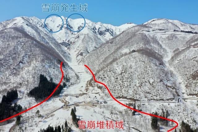
図1 今回調査した巨大雪崩の全体像。空撮写真は、発生域から堆積域までの範囲を示しています。
<関連情報>
- https://www.ffpri.go.jp/press/2026/20260925/index.html
- https://www.jstage.jst.go.jp/article/bgr/44/0/44_25A02/_article/-char/en
UAVを用いた写真測量と地上積雪調査によって明らかになった大規模雪崩の堆積特性:2021年野田松寺雪崩事例 Deposition characteristics of a large avalanche revealed by UAV–based photogrammetry and ground snow surveys: The 2021 Mt. Nodanishoji Avalanche case
Takafumi KATSUSHIMA, Satoru ADACHI, Hayato ARAKAWA, Yuta KATSUYAMA, Yukari TAKEUCHI, Katsuhisa KAWASHIMA
Bulletin of Glaciological Research Released on J-STAGE: August 19, 2026
DOI:https://doi.org/10.5331/bgr.25A02
Abstract
Field observations of large avalanches with extreme runout are crucial for enhancing our understanding of avalanche dynamics and for improving protective measures. Avalanche behavior is strongly influenced by meteorological and topographic conditions; therefore, most avalanche models rely on carefully selected parameters that are validated against historical events. However, in Japan, datasets capturing the runout extent and spatial deposition patterns of large avalanches remain scarce. This study focused on a large dry-snow slab avalanche that occurred on January 10, 2021 at Mt. Nodanishoji in Gifu Prefecture, where the runout zone contains numerous check dams for erosion and sediment control. We combined unmanned aerial vehicle (UAV)–based photogrammetry with ground snow surveys to estimate the spatial distribution of deposition thickness along with the total deposited volume and mass. Within the runout zone of 32.3 ha, the total deposition volume and mass were (5.4 ± 1.1) × 105 m3 and (2.9 ± 0.7) × 105 t, respectively, where the ± values reflect errors estimated from the deposition thickness and density measurements. Among documented events in Japan, this total deposition is second only to the March 27 Hidarimatadani Valley avalanche. Our observations further indicate that the deposition thickness decreased downstream along the flow path. The observed patterns may reflect deposition on low-slope angle runout zones containing numerous check dams, downstream valley widening, and the superposition of multiple avalanches.