2023-04-13 ジョージア工科大学
ジョージア工科大学の研究者が開発したツールは、ネットワークを最大限に活用し、水位センサーの理想的な位置をピンポイントで特定し、緊急管理者が利用できるリアルタイムのデータを最大化することができます。
<関連情報>
- https://coe.gatech.edu/news/2023/04/tool-helps-coastal-areas-find-ideal-spots-water-level-sensors
- https://www.nature.com/articles/s43247-023-00761-1
沿岸地域にリアルタイム水位センサーを設置し、複数の目的に最適化して洪水リスクを評価する。 Locating real-time water level sensors in coastal communities to assess flood risk by optimizing across multiple objectives
Iris Tien,Jorge-Mario Lozano & Akhil Chavan
Communications Earth & Environment Published:28 March 2023
DOI:https://doi.org/10.1038/s43247-023-00761-1

Abstract
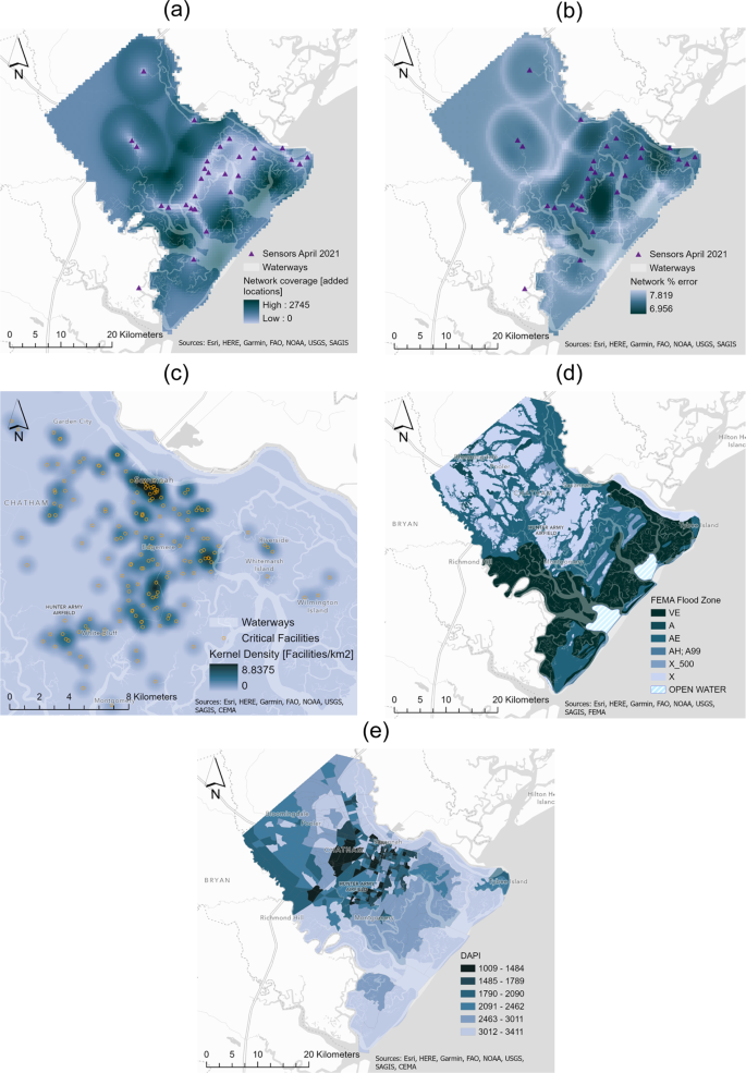
Coastal communities around the world are experiencing increased flooding. Water level sensors provide real-time information on water levels and detections of flood risk. Previous sensor installations, however, have relied on qualitative judgments or limited quantitative factors to decide on sensor locations. Here, we provide a method to optimally place real-time water level sensors across a community. We utilize a multi-objective optimization approach, including traditional measures of sensor network performance such as coverage and uncertainty, and new flood-specific parameters such as hazard estimations (flood likelihood, critical infrastructure exposure), serviceability (sensor accessibility), and social vulnerability (socio-economic index, vulnerable residential communities index). We propose a workflow combining quantitative analyses with local expertise and experience. We show the method is able to reduce the set of possible new sensor locations to just 1.3% of the full solution set, supporting effective and feasible community decision-making. The method also supports sequential expansion of a sensor network, creating a network that provides detailed and accurate real-time water level information at the hyperlocal level for flood risk assessment and mitigation in coastal communities.


