ほとんどの都市では、歩行者ネットワークを地図上で確認することはありません。今回、研究者たちは、プランナーがそれを実現するための初のオープンソースツールを構築しました。 Most cities don’t map their own pedestrian networks. Now, researchers have built the first open-source tool to let planners do just that.
2023-03-15 マサチューセッツ工科大学(MIT)
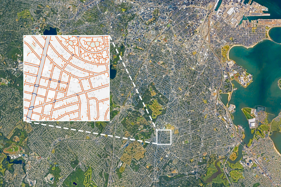
 MIT researchers have built TILE2NET, an open-source tool that uses aerial imagery and image-recognition to create complete maps of sidewalks and crosswalks. Pictured is a view of Boston with an inset showing how the model detected sidewalks, crosswalks, and footpaths.
Image: Inset courtesy of the researchers. Background via Google Earth
このツールは、ほとんどの歩行者ネットワークが未完成のままである都市において、プランナー、政策立案者、都市計画者が歩行者インフラを拡大するために開発されました。
このツールは世界中のどこでも使用でき、ボストンやケンブリッジのような場所では、すべての歩道と横断歩道の90%以上を認識することができます。
<関連情報>
- https://news.mit.edu/2023/open-source-tool-mapping-sidewalks-0315
- https://www.sciencedirect.com/science/article/pii/S0198971523000133?via%3Dihub
歩き方をマッピングする:航空写真から歩道ネットワークデータセットを生成するためのスケーラブルなコンピュータビジョンアプローチ Mapping the walk: A scalable computer vision approach for generating sidewalk network datasets from aerial imagery
Maryam Hossein, Andres Sevtsuk, Fabio Miranda, Roberto M. Cesar Jr, Claudio T. Silva
Computers, Environment and Urban Systems Available online: 22 February 2023
DOI:https://doi.org/10.1016/j.compenvurbsys.2023.101950
Highlights
- •Introduces Tile2Net, an end-to-end open-source framework for creating georeferenced pedestrian networks from aerial imagery.
- •Implements the framework on Boston, Cambridge, New York City and Washington with a relatively high degree of accuracy.
- •Demonstrates a novel technique for creating semantic segmentation annotation masks from available planimetric GIS data.
- •The tool, open-source input data links and model weights and are made publicly available.
Abstract
While cities around the world are increasingly promoting streets and public spaces that prioritize pedestrians over vehicles, significant data gaps have made pedestrian mapping, analysis, and modeling challenging to carry out. Most cities, even in industrialized economies, still lack information about the location and connectivity of their sidewalks, making it difficult to implement research on pedestrian infrastructure and holding the technology industry back from developing accurate, location-based Apps for pedestrians, wheelchair users, street vendors, and other sidewalk users. To address this gap, we have designed and implemented an end-to-end open-source tool— Tile2Net —for extracting sidewalk, crosswalk, and footpath polygons from orthorectified aerial imagery using semantic segmentation. The segmentation model, trained on aerial imagery from Cambridge, MA, Washington DC, and New York City, offers the first open-source scene classification model for pedestrian infrastructure from sub-meter resolution aerial tiles, which can be used to generate planimetric sidewalk data in North American cities. Tile2Net also generates pedestrian networks from the resulting polygons, which can be used to prepare datasets for pedestrian routing applications. The work offers a low-cost and scalable data collection methodology for systematically generating sidewalk network datasets, where orthorectified aerial imagery is available, contributing to over-due efforts to equalize data opportunities for pedestrians, particularly in cities that lack the resources necessary to collect such data using more conventional methods.


