高解像度プラットフォームにより、2,700平方マイルに及ぶ地域を10フィート単位で危険度評価 High-resolution platform assesses hazards every 10 feet across 2,700-square-mile expanse
2022-10-31 カリフォルニア大学校アーバイン校(UCI)
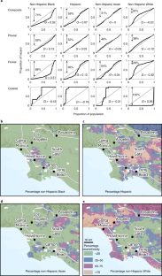
この研究結果は、最近開発された高解像度洪水モデリングプラットフォームによるもので、グレーターロサンゼルス盆地の2,700平方マイルを対象に、10フィートごとにリスクを評価することができる。この枠組みは、降雨、河川流、高潮による災害と、人口密度、民族、人種、経済的不利などの人口統計データを関連付け、Nature Sustainability誌に発表された。
<関連情報>
- https://news.uci.edu/2022/10/31/uci-flood-modeling-framework-reveals-heightened-risk-and-disparities-in-los-angeles/
- https://www.nature.com/articles/s41893-022-00977-7
カリフォルニア州ロサンゼルスの大規模かつ不公平な洪水リスク Large and inequitable flood risks in Los Angeles, California
Brett F. Sanders,Jochen E. Schubert,Daniel T. Kahl,Katharine J. Mach,David Brady,Amir AghaKouchak,Fonna Forman,Richard A. Matthew,Nicola Ulibarri & Steven J. Davis
Nature Sustainability Published:31 October 2022
DOI:https://doi.org/10.1038/s41893-022-00977-7

Abstract
Flood risks in the United States have historically been underestimated, particularly with respect to human well-being and within low-wealth and marginalized communities. Here, we characterize a fuller range of risks in Los Angeles, California, using a quantitative framework that intersects flood hazards from rainfall, streamflow and storm tides with measures of exposure and vulnerability including ethnicity, race and socioeconomic disadvantage. We find that between 197,000 and 874,000 people (median 425,000) and between US$36 billion and US$108 billion in property (median US$56 billion) are exposed to flooding greater than 30 cm within the 100-year flood zone, risk levels far above federally defined floodplains and similar to the most damaging hurricanes in US history. These risks are disproportionately higher for non-Hispanic Black and disadvantaged populations, burdening communities that may have greater challenges recovering and reinforcing socioeconomic inequities. Our framework creates opportunities for transparently and equitably reducing flood risks in urban areas.


